
Dividing your map according to popular geographic boundaries is a fantastic way to create sales territories and analyze demographic information. U.S. zip codes are a popular boundary in the map, so it’s typically a decent starting point.
Creating a map from a zip or postal code
Although Excel can implement mapping options using zip or postal code, it’s often complicated. To start:
- Open your Excel program and enter all applicable data into the spreadsheet with the ZIP codes and values.
- Once all information is in the spreadsheet, select the geography data type (in this case, ZIP codes and select the Data button on the program.
- Follow the menu to Data Tyles and Geography to format the cells within the spreadsheet. The data will automatically convert into a geography data type.
From there, users can add columns to the data as required.
Once you’ve finished arranging the data, select the cells you’d like to turn into a map. Select the Insert tab and choose the Charts> Maps> Filled Map function. Excel will read the ZIP codes entered and create a map chart using those details. The low values will display light colors, while higher values show darker saturation. The map chart will preview on the screen; click “OK” to confirm.
Creating a Map with Mapping Software
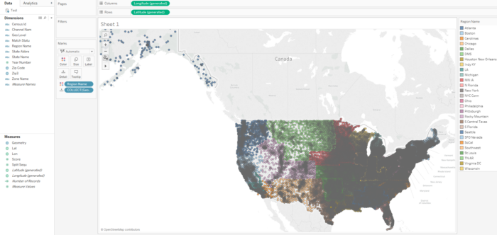
Instead, many businesses rely on third-party mapping software to develop a territory map by zip code. The mapping software is easier to navigate, particularly regarding extensive entries. Users can automatically create boundaries surrounding the postal or zip code, which further analyzes towns and major cities (which may not have the same zip code throughout).
Many mapping programs allow free trials, which can help you become accustomed to the software navigation early on.
To get started:
- Choose your mapping software and log into the application.
- Select the “Create My First Map” button and give it a name and description.
- Select continue to find the data upload page.
Users can often enter the data manually, copy and paste the information, or upload the spreadsheet into the program.
Select the Map options button and choose the boundary tool within the dashboard. Users can choose the zip or postal code option, depending on the country they’re looking at. From there, select the boundary fill type. The most popular options are marker count or location density, territory data, or your numerical input.
But what if a user wants to outline something other than the traditional five-digit code?
Currently, the United States holds four different types of zip codes used by the United States Postal Service. These options include:
P.O. Box Zip Codes: All P.O. Boxes are given a unique zip code
Unique Zip Codes: A few addresses receive large amounts of mail and are offered their zip code
Military Zip Codes: These zip codes apply to any correspondence or deliveries sent to U.S. Military
Standard Zip Codes: Any address that doesn’t fall into the above category will receive a standard zip code.
What are 3 Digit Zip Codes?
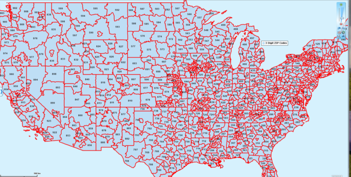
The three-digit zip code is the first three numbers in a standard code. Each zip code in the United States is divided into three parts. The first is the national area, which divides the country into ten groups. The first digit will indicate which one of those groups the address belongs to. The regional one is a smaller geographic region (typically ten per state) determined by the following two digits of the zip code. These areas hold a specific sectional center facility that sorts and distributes mail. Finally, the delivery area is the last two digits of a zip code. This is the area that mail is delivered to.
Should I Use 3-Digit Zip Codes instead of 5-Digit Zip Codes?
Standard zip codes are typically the most common geographic boundary but can be relatively small compared to other boundary limits. These codes can help establish sales territories (by combining zip codes into more significant areas to use), create distribution areas (help determine distribution centers throughout a city), or determine the demographics of larger sizes (reviewing data for larger geographic areas). The three-digit code is the ideal alternative if you’d like to divide cities into multiple areas.

")


